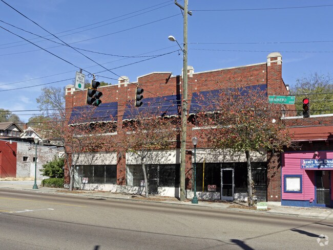
Property Record
3221 Brainerd Rd, Chattanooga, TN 37411

NEARBY LISTINGS FOR SALE OR LEASE
Property Detail
3221 Brainerd Rd
Chattanooga, TN-GA
Whitley And Worsham Resubdivision
146M-M-027
LT 2 WHITLEY AND WORSHAN PB 10 PG 11 REV PB 57 PG 280 REV PB 99 PG 187 FOR 2014
Storebuilding
Hamilton
X
Tennessee
47065C0344G
2
2024
0.30 AC
2024
Outlying Chattanooga
002900
Chattanooga
8,178 SF
DEMOGRAPHICS near 3221 Brainerd Rd
1 Mile
3 Mile
5 Mile
2024 Total Population
9,373
74,612
152,738
2029 Population
10,052
80,215
163,318
Pop Growth 2024-2029
+ 7.24%
+ 7.51%
+ 6.93%
Average Age
40
38
39
2024 Total Households
3,994
29,877
64,964
HH Growth 2024-2029
+ 7.29%
+ 7.75%
+ 7.20%
Median Household Inc
$46,160
$42,758
$46,312
Avg Household Size
2.20
2.30
2.20
2024 Avg HH Vehicles
2.00
2.00
2.00
Median Home Value
$241,005
$173,825
$185,858
Median Year Built
1957
1960
1967
Nearby Places
Map Layers
Map Styles
 Street
 Aerial
- Restaurants
- Banks
- Shops
- Fitness
- Groceries
PUBLIC TRANSPORTATION
AIRPORT
Lovell Field
DRIVE
WALK
Distance
Lovell Field
11 min
4.7 mi
SALE & LEASE HISTORY
LISTING DATE
SALE/LEASE

Sep 25, 2016
For Lease
Jul 23, 2019
For Lease
Nearby Properties
Address
Land Use
TOTAL SIZE
Lot Size
Zoning
Address
Land Use
TOTAL SIZE
Lot Size
Zoning
91,908 SF
2.64 AC
C3
Address
Land Use
TOTAL SIZE
Lot Size
Zoning
192,000 SF
3.09 AC
R4
Address
Land Use
TOTAL SIZE
Lot Size
Zoning
306,411 SF
6.96 AC
Address
Land Use
TOTAL SIZE
Lot Size
Zoning
170,000 SF
2.25 AC
C3
Address
Land Use
TOTAL SIZE
Lot Size
Zoning
308,635 SF
2.24 AC
M1
Address
Land Use
TOTAL SIZE
Lot Size
Zoning
351,776 SF
17.70 AC
R4
Address
Land Use
TOTAL SIZE
Lot Size
Zoning
134,974 SF
3.22 AC
Address
Land Use
TOTAL SIZE
Lot Size
Zoning
52,209 SF
3.43 AC
C2
Address
Land Use
TOTAL SIZE
Lot Size
Zoning
43,470 SF
1.26 AC
R4
Address
Land Use
TOTAL SIZE
Lot Size
Zoning
298,953 SF
16.26 AC
R3
Address
Land Use
TOTAL SIZE
Lot Size
Zoning
70,190 SF
6.05 AC
R4
Address
Land Use
TOTAL SIZE
Lot Size
Zoning
5.05 AC
R3
Address
Land Use
TOTAL SIZE
Lot Size
Zoning
4.27 AC
9999
Address
Land Use
TOTAL SIZE
Lot Size
Zoning
790,207 SF
53.84 AC
C2
Address
Land Use
TOTAL SIZE
Lot Size
Zoning
5,888 SF
10.20 AC
R3
Address
Land Use
TOTAL SIZE
Lot Size
Zoning
24.75 AC
Address
Land Use
TOTAL SIZE
Lot Size
Zoning
81,510 SF
9.98 AC
R4
Address
Land Use
TOTAL SIZE
Lot Size
Zoning
138,674 SF
1.50 AC
C2
Address
Land Use
TOTAL SIZE
Lot Size
Zoning
6.32 AC
M1
Address
Land Use
TOTAL SIZE
Lot Size
Zoning
3.47 AC
R3
Address
Land Use
TOTAL SIZE
Lot Size
Zoning
87,337 SF
1.47 AC
9999
Address
Land Use
TOTAL SIZE
Lot Size
Zoning
373,949 SF
29.50 AC
Address
Land Use
TOTAL SIZE
Lot Size
Zoning
59,544 SF
4.10 AC
R3
Address
Land Use
TOTAL SIZE
Lot Size
Zoning
215,385 SF
14.10 AC
UR
Address
Land Use
TOTAL SIZE
Lot Size
Zoning
50.82 AC
C2
Address
Land Use
TOTAL SIZE
Lot Size
Zoning
151,314 SF
6.60 AC
Address
Land Use
TOTAL SIZE
Lot Size
Zoning
54,534 SF
4.51 AC
R3
Address
Land Use
TOTAL SIZE
Lot Size
Zoning
91,448 SF
R1
Address
Land Use
TOTAL SIZE
Lot Size
Zoning
55,289 SF
9.33 AC
C2
Address
Land Use
TOTAL SIZE
Lot Size
Zoning
29,010 SF
1.03 AC
R4
The World's #1 Commercial Real Estate Marketplace
Connect with us
© 2025 CoStar Group
The information above has been obtained from sources believed reliable. While we do not doubt its accuracy we have not verified it and make no guarantee, warranty or representation about it. It is your responsibility to independently confirm its accuracy and completeness. Any projections, opinions, assumptions, or estimates used are for example only and do not represent the current or future performance of the property. The value of this transaction to you depends on tax and other factors which should be evaluated by your tax, financial, and legal advisors. You and your advisors should conduct a careful, independent investigation of the property to determine to your satisfaction the suitability of the property for your needs.